The morning light catches the spray from a peeling wave, the sound a steady roar against the shore of Lagundri Bay. Palm fronds rustle in the gentle breeze, a constant rhythm accompanying the ocean’s pulse. This is Nias, an island off Sumatra’s western coast, defined by its powerful waves and the deep blue expanse of the Indian Ocean.
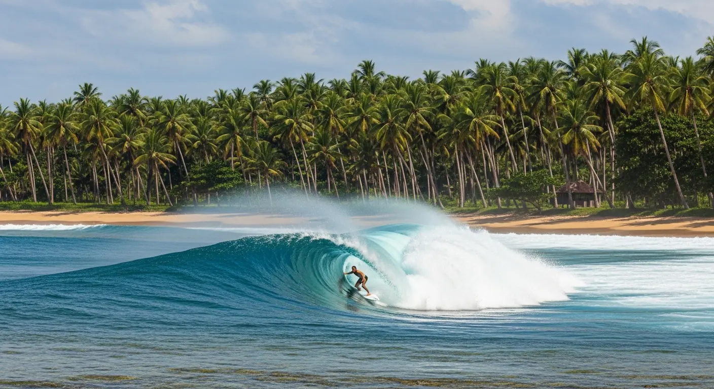
Lagundri Bay: The Enduring Right-Hand Point
Lagundri Bay, on Nias Island, remains the primary draw for surfers seeking the iconic right-hand point break. This reef break is renowned for its consistent, long-period swells that transform into powerful, rideable waves. The earliest known surf camp in the Nias area was established here around 1975, cementing its status as a pioneering surf destination. The bay faces southwest, optimally receiving swells generated in the southern Indian Ocean. Wave heights commonly range from 4 to 12 feet on favorable days, with larger swells possible during peak season. Surfers navigate a coral reef, a natural formation that shapes the wave’s consistent wall and barrel sections. Access to the lineup typically involves a paddle out from the beach at Sorake, which borders Lagundri. The wave itself offers multiple sections, from the initial take-off to the inside bowl, demanding precision and experience. During the optimal surf season, from May to September, consistent groundswells impact the Nias coast. Specific tide conditions influence the wave’s performance; mid-tide often provides the most forgiving and rideable face. The Nias Island landmass, covering approximately 5573 square kilometers, provides a substantial barrier against prevailing winds, often resulting in favorable offshore conditions for Lagundri. The population of Nias Island was estimated at 946746 people in mid-2024, reflecting a vibrant local community alongside the transient surf population.
Navigating Nias Reef Breaks Beyond Lagundri
While Lagundri Bay dominates the Nias surf narrative, the island presents other significant reef breaks for exploration. These breaks often require local knowledge and guiding for safe and effective access. Beyond the main point, several satellite breaks within Lagundri Bay itself offer different challenges and wave characteristics, depending on swell direction and size. These include waves like “The Keyhole” or “Indicator,” which break on specific reef formations. Further afield, breaks on the island’s western and northern coasts activate with specific swell directions, typically during the same Indonesian surf season. These outer reefs often remain uncrowded, offering a stark contrast to the sometimes-busy Lagundri lineup. However, the remote nature of these spots necessitates careful planning, including boat access and considerations for reef safety. Surf guides familiar with Nias Island travel are crucial for identifying optimal conditions and safe entry/exit points for these less-frequented breaks. The Nias Regency, covering a portion of Nias Island, had an official mid-2024 population estimate of 155629 residents, indicating a dispersed population across the island’s varied topography.
Surf Seasons and Access Considerations for Nias Island
The Indonesian surf season, particularly for Nias, spans from May to September, coinciding with the southern hemisphere’s winter swells. During these months, consistent groundswells from the Indian Ocean impact the exposed western coast of Nias Island. Swell periods can range from 12 to 20 seconds, producing powerful, organized waves. Outside of this primary window, from October to April, the island still receives surf, though with less consistency and often smaller wave sizes. This “off-season” can offer uncrowded conditions for those willing to accept less predictable surf. Air travel to Nias Island typically involves a flight to Kualanamu International Airport (KNO) near Medan, Sumatra, followed by a domestic flight to Binaka Airport (GNS) near Gunungsitoli, Nias. From Gunungsitoli, ground transport to Lagundri Bay takes approximately 2-3 hours, covering a distance of about 70 kilometers. Ferry services also connect Nias to Sibolga on Sumatra, though this journey is considerably longer. Nias Island is located at approximately 1.100 degrees north latitude and 97.533 degrees east longitude, positioning it squarely within the equatorial zone, resulting in consistent tropical temperatures year-round, averaging 27-30 degrees Celsius.
Surfboard Rentals and Guiding in Nias
For surfers traveling to Nias, options exist for surfboard rentals, though selection can be limited compared to major surf destinations. Most surf camps and guesthouses in the Lagundri Bay area offer a modest quiver of boards, typically catering to intermediate and advanced surfers with shortboards or funboards. Renting a board upon arrival can be a viable option, but bringing a personal board, especially if specific dimensions or fin setups are preferred, is generally recommended for optimal performance on Nias’s powerful waves. Repair services for dinged boards are also available locally, often by skilled craftsmen. Surf guiding in Nias is a valuable service, particularly for those unfamiliar with the specific nuances of Lagundri Bay or seeking to explore lesser-known breaks. Experienced local guides possess in-depth knowledge of tide charts, swell directions, wind patterns, and reef hazards. They can advise on optimal surf times, assist with understanding the lineup, and ensure safety in challenging conditions. Guides can also facilitate transport to other breaks via boat or vehicle. Engaging a local guide not only enhances the surf experience but also supports the local economy and provides insight into the unique Nias culture.
Nias Island: A Geographical and Cultural Overview
Nias Island is a substantial landmass off the western coast of Sumatra, Indonesia. Its geographical coordinates, approximately 1.100 degrees north latitude and 97.533 degrees east longitude, place it just north of the equator. The island’s area, approximately 5573 square kilometers, supports a diverse landscape of rolling hills, dense jungle, and coastal plains. The geology of Nias is characterized by its position within the Sunda Arc, a tectonically active region. The island has experienced significant seismic activity, shaping its rugged coastline and contributing to the formation of its world-class reef breaks. The population of Nias Island was estimated at 946746 people in mid-2024, distributed across various regencies and administrative districts. Nias Regency, for instance, had an official mid-2024 population estimate of 155629 residents. The indigenous people of Nias, known as the Niasan (Ono Niha), have a rich cultural heritage, famous for their megalithic stone carvings, traditional houses (omo sebua), and unique ceremonies, including stone jumping (fahombo batu). While surfing has introduced a modern element, the island retains deep cultural roots. The island’s economy is primarily agricultural, with rubber, coconut, and rice being significant crops, alongside fishing and, increasingly, tourism. For more detailed information on the island’s geography and history, consult Wikipedia’s entry on Nias.
For comprehensive information and detailed planning for your Nias surf trip, explore the resources available at niascamp.com.